
Did you know that 90% of people are more likely to visit a business that features photos on Google Search and Maps?
As local SEO evolves, many marketers are asking a pressing question: Does geotagging images still influence rankings, or is it an outdated tactic?
The intersection of digital imagery and geospatial metadata has become one of the most debated topics in local search optimization. Geotagging involves embedding geographic coordinates such as latitude and longitude into digital files, including photos and videos. For years, businesses believed these coordinates strengthened local relevance signals. However, as search engines shift toward entity-based indexing, artificial intelligence, and advanced visual recognition systems, the actual impact of embedded metadata has come under closer examination.
In this article, you will learn how geotagging works, whether it directly affects local search rankings, what official guidance from major search providers reveals, and how AI-driven visual analysis is reshaping the way search engines interpret location signals.
How Photo Geotagging Works: Technical Architecture and Metadata Standards
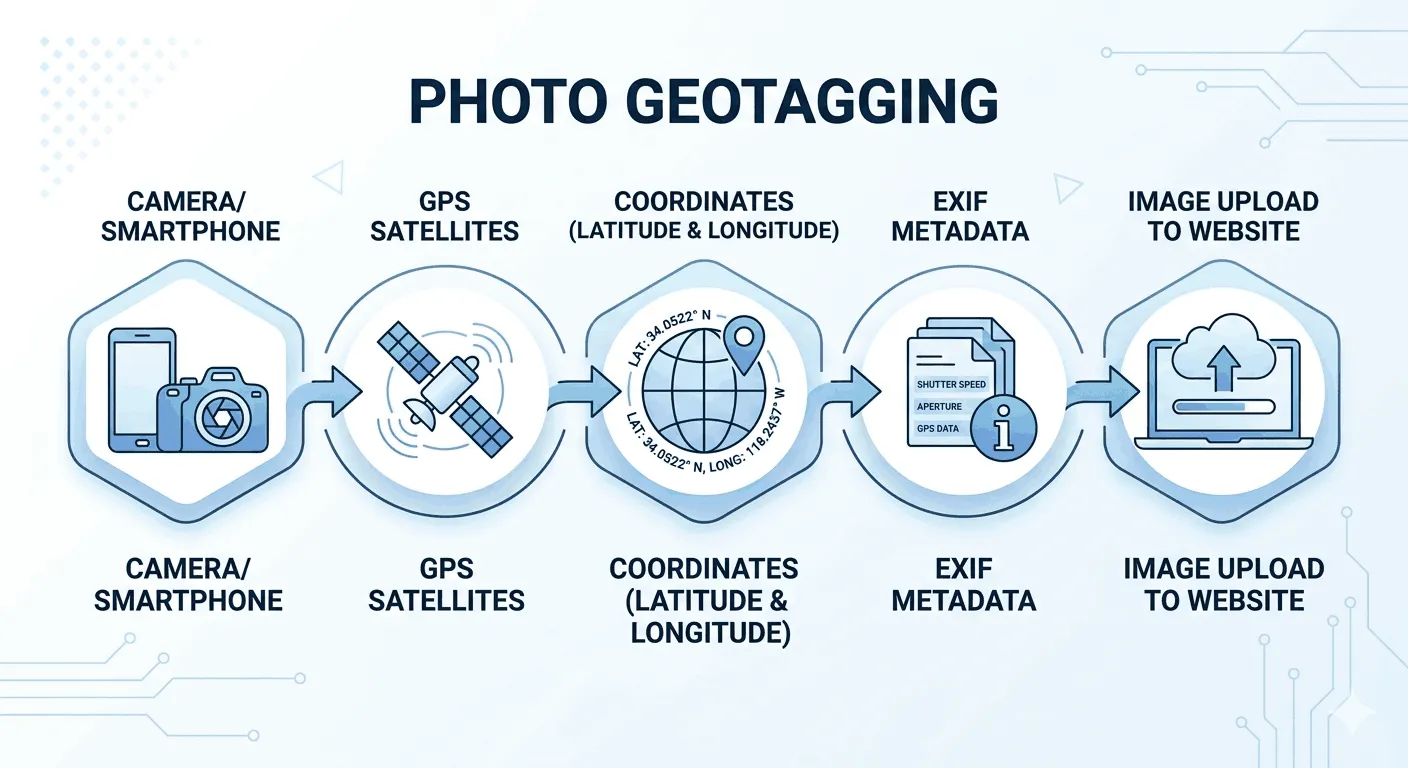
Before you decide whether geotagging helps your local SEO, you need to understand how it actually works behind the scenes. When you upload an image to your website, that file may contain hidden location data stored inside its metadata.
This metadata is not visible to your website visitors, but search engines and software tools can read it. The most common system used to store this information is called EXIF.
Let’s break it down in simple terms.
What Is EXIF Data in Photo Geotagging?
EXIF stands for Exchangeable Image File Format. It is the standard most smartphones and digital cameras use to store technical and location data inside image files.
When you take a photo, your device records more than pixels. It saves details such as:
- Camera model
- Aperture
- Shutter speed
- ISO
- Date and time
- GPS coordinates
This data is stored in a hidden section of JPEG or TIFF files.
If your device has location services enabled, it writes latitude and longitude into a specific part of EXIF called the GPS sub-IFD. This is where photo geotagging happens at a technical level.
In many cases, it can also store:
- Altitude
- Direction the camera was facing
- Exact capture timestamp
This is the core technical foundation behind image geotagging in local SEO discussions.
Key Metadata Standards Used in Geotagging
EXIF is not the only metadata system available. Several standards exist, each serving a different purpose. Understanding them helps you see how structured image metadata works in digital search environments.
Below is a comparison of the most important metadata standards used in digital imagery and geospatial data.
Before reviewing the table, here is what you will learn: the function of each metadata standard and how location data is stored within image files.
Metadata Standards for Photo Geotagging and Image Data
| Metadata Standard | Primary Function | Storage Mechanism |
| EXIF | Captures technical camera settings and GPS coordinates at the moment of capture. | Binary header within JPEG and TIFF files. |
| IPTC | Stores administrative and descriptive data like copyright, creator, and credit information. | Embedded directly or stored as an external sidecar file. |
| XMP | An extensible platform developed by Adobe for managing a wide range of metadata. | XML-based, allows custom fields beyond standard EXIF. |
| GeoTIFF | Specialized standard for satellite and aerial imagery. | Coordinates mapped to every pixel for orthorectification. |
In short, EXIF handles most photo geotagging tasks for local businesses, while GeoTIFF is used in advanced mapping and remote sensing applications.
How GPS Coordinates Are Embedded in Images
Now let’s look at how geographic coordinates are actually stored.
Modern devices rely on the Global Positioning System. GPS uses decimal degrees based on the WGS84 coordinate system. When you capture a photo with location enabled, your device:
- Connects to GPS satellites
- Calculates latitude and longitude
- Writes those values into the EXIF GPS directory
In smartphones, this process is usually automatic. Cellular networks often assist GPS to reduce signal acquisition time. That is why your phone can tag a location quickly even indoors or in urban areas.
If you disable location services, the image will not contain embedded GPS data.
Automatic vs Manual Geotagging: What’s the Difference?
There are two main ways geotagging is applied to digital images.
Automatic Geotagging
This happens when your device has built-in GPS. The coordinates are written instantly at the moment of capture.
You do not need to take extra steps. Most modern smartphones use this method by default.
Manual Geotagging
This method is used when you add location data after the image has been taken.
You can use:
- Photo editing software
- SEO tools
- Dedicated geotagging applications
In manual geotagging, you select a point on a map and insert those coordinates into the file header.
From an SEO perspective, both methods produce the same type of embedded EXIF GPS data. The difference lies in how the data gets there.
Geotagging vs Georeferencing: Understanding the Technical Difference
Many people confuse geotagging with georeferencing, but they are not the same.
Geotagging assigns a single set of coordinates to the entire image. It tells you where the photo was taken.
Georeferencing is more advanced. It assigns coordinates to every pixel in a raster image. This is used in satellite imagery, mapping, and cartography. GeoTIFF files are a common example.
If you are managing a local business website, you are dealing with geotagging, not georeferencing.
The History of Geotagging in Local SEO
To understand why photo geotagging became popular, you need to look at how local SEO evolved over time.
Local search became a distinct area of SEO around 2004. Search engines began showing results based on the user’s physical location. If someone searched for a service nearby, the engine tried to return businesses within that area.
As a business owner or marketer, you likely want to send strong local signals. In the early days, that meant focusing on simple elements like your Name, Address, and Phone number consistency across directories.
As smartphones became common and digital photography exploded, a new idea emerged. If your photos contained embedded GPS coordinates, could that act as proof that your business operates in a specific location?
This question marked the rise of geotagging as an SEO tactic.
How Local SEO Evolved Over Time
Before we examine whether geotagging works, it helps to see how local ranking factors have shifted across different eras.
Below is a structured overview of how local SEO priorities changed and where imagery fit into the picture.
This table shows how the role of images and geotagging evolved in local search strategy.
Evolution of Local SEO and the Role of Image Geotagging
| Era | Primary Local SEO Focus | Role of Imagery |
| 2004–2010 | NAP Citations and Directory Listings | Secondary, mostly used for visual branding. |
| 2011–2015 | Mobile-Friendliness and Knowledge Graph | Introduction of Google My Business; images used for profile completion. |
| 2016–2022 | Semantic Intent and “Near Me” Queries | Rise of geotagging as a perceived tactic for local relevance. |
| 2023–Present | AI-Driven Personalization and Visual Search | Shift toward computer vision and multimodal intent over metadata. |
The pattern is clear. As search engines became more advanced, their methods for determining local relevance also became more sophisticated.
Why Geotagging Became Popular in Local Search Optimization
The logic behind image geotagging was simple.
If you uploaded a photo of your storefront or a completed project, and that photo contained embedded GPS coordinates, search engines might interpret that data as confirmation of your physical presence in that area.
For businesses trying to rank in the local Map Pack, this sounded promising.
The Map Pack refers to the top three local listings shown alongside a map in search results. For many service-based businesses, appearing there can drive significant traffic and calls.
Because competition in local SEO increased over time, marketers began searching for additional ranking signals. Geotagging was promoted in online forums and SEO communities as a way to strengthen local relevance, especially for:
- Service-area businesses
- Contractors and home services
- Businesses struggling to rank in competitive cities
At one point, geotagging was even described as a hidden tactic that many competitors were ignoring.
The Debate: Is Geotagging a Local Ranking Factor or a Myth?
As the SEO industry matured, opinions began to split.
Supporters argued that embedded EXIF GPS data provides structured location signals that search engines could use.
Skeptics raised an important concern. Image metadata can be edited easily using free online tools. If anyone can insert coordinates into a photo within minutes, can that data really be trusted as a ranking signal?
This is where the discussion becomes more nuanced.
Search engines aim to reduce manipulation and spam. Over time, they shifted from relying on easily editable signals toward more advanced systems such as entity recognition, user behavior data, and AI-driven visual analysis.
So while geotagging gained popularity as a local SEO tactic during the rise of “near me” searches, its actual weight in modern search algorithms remains widely debated.
Do Search Engines Use Image Metadata for SEO Rankings?
Now you reach the core question: Do search engines actually read and use embedded image metadata like EXIF for ranking?
When it comes to Google, the public answer has remained consistent. Metadata may be used for context or discovery, but it is not treated as a direct ranking factor.
Over the years, representatives from Google have explained that while EXIF data can be accessed, there is no need to geotag images specifically for SEO purposes. Analysts such as John Mueller and Martin Splitt have reiterated this point in webmaster discussions.
So if you are geotagging photos purely to boost rankings, official guidance suggests it is not required.
That said, the full picture is more technical.
What Happens to EXIF Data After You Upload an Image?
To understand whether metadata can influence rankings, you need to know what happens during image processing.
When you upload an image to platforms such as Google Business Profile, the file often undergoes metadata stripping.
What Is Metadata Stripping?
Metadata stripping removes EXIF and IPTC data from the publicly served version of an image. This happens for two main reasons:
- User privacy protection
- Faster loading speeds and reduced file size
If the metadata is removed from the final image, critics argue it cannot influence rankings.
However, there is another perspective.
Some analysts suggest that search engines may extract metadata during the initial crawl or upload phase before stripping it from the publicly displayed file. If that is true, metadata could still be read at an early stage even if it does not remain attached to the served version.
There is no official confirmation that this affects rankings. But technically, it is possible for metadata to be analyzed during discovery.
How Google Processes Images Beyond Metadata
Even if EXIF data is not a direct ranking factor, image processing inside Google’s systems is far more advanced than simple metadata reading.
Internally, Google has used large-scale image processing frameworks, historically referred to by names such as “Amarna.” These systems evaluate images using machine learning models.
One example is Neural Image Assessment, often abbreviated as NIMA. These models score images based on:
- Technical quality such as lighting and focus
- Visual composition
- Overall aesthetic appeal
In this context, embedded metadata is treated more as a provenance signal. It may help confirm origin or copyright information, but it is not considered a primary ranking driver.
This reflects a larger shift toward AI-based image understanding rather than reliance on editable file headers.
How Search Engines Handle Image Metadata: Process Breakdown
To make this clearer, here is a structured overview of how search engines interact with image metadata during different stages.
This table explains what happens to EXIF and IPTC data during crawling, indexing, and quality analysis.
Search Engine Image Processing and Metadata Handling
| Search Engine Process | Action on Metadata | Purpose |
| Crawling | Possible extraction of EXIF/IPTC during initial discovery. | Understanding provenance and technical origins. |
| Indexing | Metadata often stripped for public serving. | Privacy protection and bandwidth optimization. |
| Quality Scoring | Analysis using Neural Image Assessment models. | Identifying high-quality, relevant visual content. |
| Semantic Analysis | Optical Character Recognition reads visible text in images. | Matching visual content to specific search queries. |
In simple terms, metadata may be read early in the process, but long-term ranking signals rely far more on image quality, semantic context, and visible content.
Why Visual Content Analysis Matters More Than Geotagging
Search engines now use:
- Computer vision
- Optical Character Recognition to read text in signs or menus
- Multimodal AI systems that combine text, image, and intent
If you upload a storefront photo, the system may analyze:
- The building appearance
- The signage text
- The surrounding environment
This means your visible content often carries more weight than hidden GPS coordinates.
For you as a business owner or SEO strategist, the takeaway is clear. Optimizing image quality, context, and relevance to your page matters more than manually inserting latitude and longitude into the file.
Does Geotagging Improve Local Rankings? What Real SEO Experiments Show
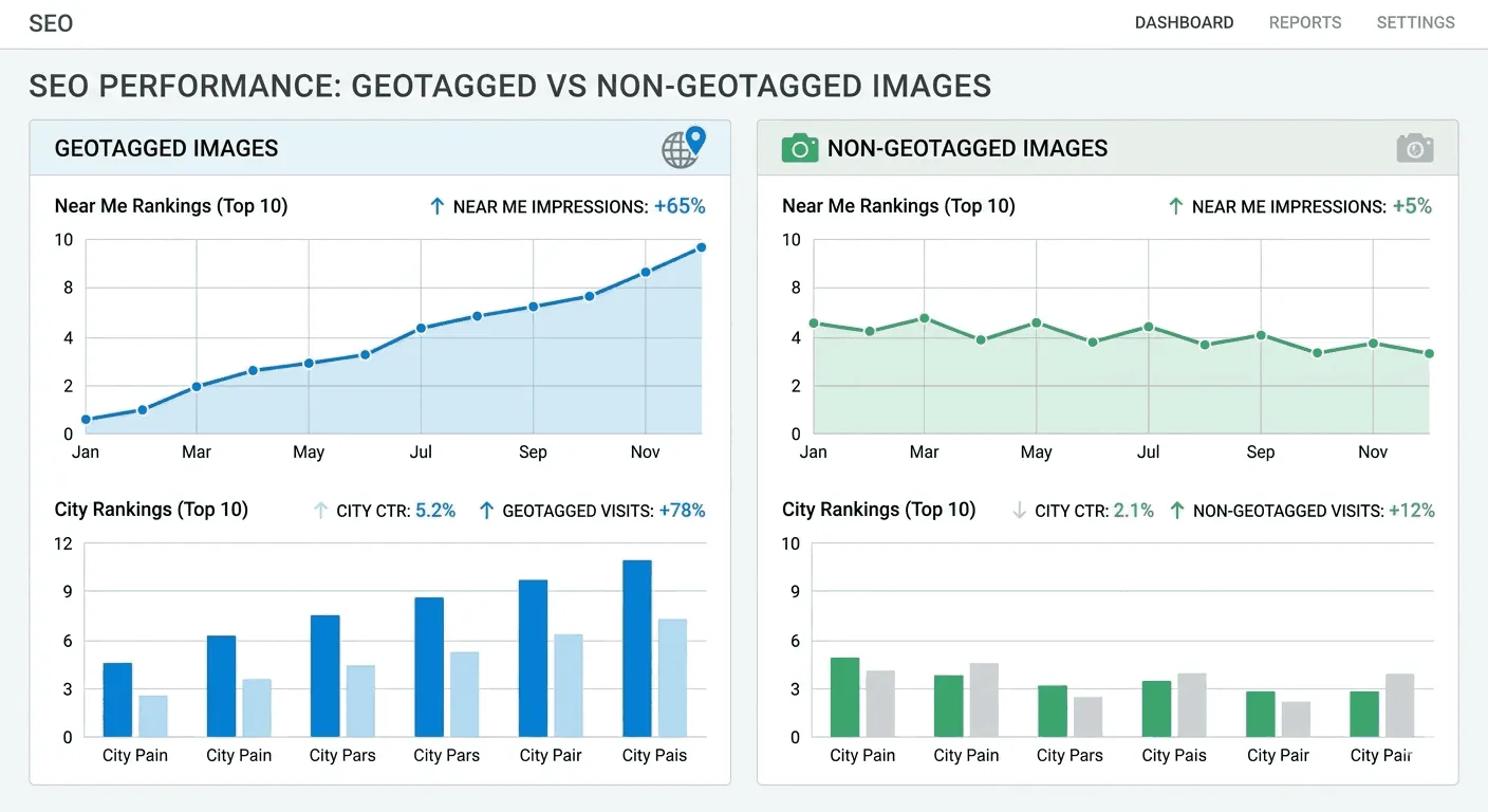
You have seen the theory. Now let’s look at the data.
To move beyond opinions, several researchers ran controlled local SEO experiments to test whether geotagging images affects rankings inside Google Business Profile. Since GBP drives Map Pack visibility, it is the best place to measure local ranking changes.
Here’s what the evidence actually shows.
The Joy Hawkins and Tim Kahlert Studies: No Ranking Impact Found
In early 2024, Joy Hawkins from Sterling Sky conducted a controlled test across five different GBP listings.
She monitored ranking changes over several weeks after adding geotagged EXIF coordinates to uploaded images.
The result was clear. There was no measurable improvement in local rankings.
A separate study by Tim Kahlert reached the same conclusion. Geotagging images did not change how businesses ranked in local search results.
For you, this suggests that simply embedding latitude and longitude into image metadata does not automatically boost Map Pack visibility.
The Evergrow Marketing Experiment: Mixed Results
Later in 2024, Evergrow Marketing conducted a larger 10-week study involving 54 business locations.
This experiment tracked seven ranking metrics, including:
- “Near me” queries
- City-specific keywords
- Overall position changes
The results were more complex.
1. Impact on “Near Me” Queries
For searches such as “plumber near me,” the study found:
- Rankings improved 70% of the time
- Statistical certainty reached 97%
This suggests geotagging may send a hyper-local signal tied to very specific coordinates.
If your strategy relies heavily on “near me” searches, this finding is worth noting.
2. Impact on City-Specific Queries
For searches that included a city name, such as “lawn care Salt Lake City,” the results were different.
The study observed a decrease in rankings during the test period.
This indicates that embedding precise coordinates may narrow perceived relevance to one point rather than the broader city.
3. Overall Ranking Movement
When comparing total ranking increases:
- The control group, where metadata was stripped before upload, performed 76% better overall
- The geotagged test group showed weaker total position gains
This is a significant finding.
What These Local SEO Case Studies Mean for You
When you compare all experiments together, a pattern emerges:
- Smaller tests found no measurable impact
- Larger tests showed limited benefits for “near me” searches
- Broader city-wide visibility sometimes declined
One possible explanation is how search engines interpret precision.
If you embed exact coordinates, the system may associate your business strongly with that single geographic point. That could help in ultra-local searches. However, it may reduce perceived relevance across the surrounding metropolitan area.
In practical terms, geotagging may narrow your visibility rather than expand it.
Clear Takeaway from the Data
Here is what current empirical evidence suggests:
- Geotagging is not a confirmed ranking factor
- It does not consistently improve Map Pack rankings
- It may influence hyper-local “near me” intent in certain cases
- It can potentially limit broader city-level visibility
If your goal is sustainable local SEO growth, relying solely on embedded EXIF coordinates is not supported by strong evidence.
How Computer Vision and Visual Search Are Changing Local SEO

As traditional image metadata becomes less central to rankings, search engines now rely heavily on artificial intelligence and computer vision to interpret visual content.
If you want your images to support your local SEO strategy, you need to understand how this shift works.
Tools like Google Lens allow users to search by pointing their camera at:
- A storefront
- A restaurant menu
- A product
- A landmark
Instead of reading hidden EXIF data, search engines now analyze what they can actually see inside the image.
What Is Multimodal Search and Why It Matters for Your Images?
Modern search systems are multimodal. That means they combine text, images, and context to understand user intent.
When you upload a photo, search engines analyze:
- Shapes
- Edges
- Textures
- Patterns
- Visible text
This visual data is then connected to entities inside Google’s index and Knowledge Graph.
A major part of this process is Optical Character Recognition, or OCR.
How OCR Strengthens Local Relevance
OCR allows search engines to read text within images. For example:
- Your business name on a storefront sign
- Opening hours on your door
- A branded menu inside your restaurant
If the system can visually confirm your business name and location from the image itself, it does not need embedded GPS coordinates to validate where the photo was taken.
In practical terms, visible proof beats hidden metadata.
Visual Signals That Influence Local Search Visibility
To make this clearer, here is how specific visual elements contribute to local SEO performance.
Before reviewing the table, here is what you will learn: which visible signals inside your images support search engines in verifying your business identity and relevance.
Visual SEO Signals and Their Ranking Impact
| Visual Signal | SEO Mechanism | Ranking Benefit |
| Signage/Branding | OCR Extraction | Verifies business entity and location. |
| Neighborhood Landmarks | Entity Association | Strengthens local authority for a specific area. |
| Product Details | Object Identification | Improves visibility for product-specific local searches. |
| Team/Staff Photos | Trust Signal | Enhances user trust and click-through rates. |
This shows a clear pattern. What search engines can see and interpret visually carries more weight than what is hidden in EXIF fields.
Why Authentic Images Increase Trust and Engagement
Beyond rankings, imagery strongly affects user behavior.
Trust drives local purchasing decisions. When someone finds your listing, they silently ask:
Can I trust this business?
Research shows that 98% of consumers believe authentic images and videos are crucial in building trust.
That means your photos are not just decorative. They directly influence whether someone chooses you or your competitor.
Authentic Photos vs Stock Images: What Users Actually Trust
Consumers have become highly skilled at spotting stock photography. Many users distrust heavily edited or generic images.
Eye-tracking studies show that people often ignore stock photos and focus instead on real faces and genuine environments.
Here is how different content types influence consumer behavior.
Before reviewing the table, this breakdown explains how image type impacts trust and visit likelihood.
Image Type and Consumer Trust Levels
| Content Type | Consumer Trust Level | Impact on Visit Likelihood |
| Genuine Business Owner Photo | High (52%) | Most likely to inspire a visit. |
| Generic Product/Office Photo | Moderate (33%) | Helpful but less personal. |
| No Photo | Low (16–21%) | High risk of being overlooked. |
| User-Generated Content (UGC) | High | Deepens engagement through peer validation. |
The takeaway is simple. Real images build confidence. Generic visuals do not.
How Images Improve Google Business Profile Engagement
If you manage a listing on Google Business Profile, images play a measurable role in engagement.
Businesses with photos are:
- 90% more likely to receive visits from search results
- 42% more likely to receive requests for driving directions
These numbers highlight something important. The value of your images lies in their ability to answer a practical question for the user:
Is this business legitimate and suitable for me?
When your photos clearly show your location, staff, products, and environment, you reduce uncertainty. That increases clicks, calls, and visits.
The Strategic Shift: Optimize for Visibility, Not Hidden Metadata
If you focus on local SEO today, your priority should be:
- Clear storefront photos
- Visible signage
- Recognizable neighborhood context
- Real team and customer interactions
- High image quality
Computer vision and multimodal search systems reward context-rich, authentic visuals.
Hidden GPS tags alone cannot compete with visible proof.
Privacy and Security Risks of Geotagging Images
While geotagging can offer some hyper-local SEO benefits, it also comes with real privacy and security risks that cannot be ignored. Embedding precise location data in photos or videos can reveal your whereabouts, your business location, or other sensitive information to anyone who gains access to the file.
Understanding these risks is crucial before you decide to use geotagging as part of your digital strategy.
How Geotags Can Expose You and Your Business
Geotagged images can be exploited by malicious actors in several ways:
- Personal Safety: Cyberstalkers or predators can track routines or frequent locations.
- Property Risk: Sharing photos of valuable equipment or home offices can inadvertently broadcast your assets to potential burglars.
- Travel Vulnerability: Posting geotagged photos in real time while on vacation signals that your home is empty.
Even if you think your metadata is hidden, modern AI tools make location detection easier than ever.
AI Tools Can Reveal Locations Even Without Metadata
AI-powered geolocation platforms like GeoSpy can identify a photo’s location using visual clues alone:
- Architectural style of buildings
- Sunlight and shadow patterns
- Vegetation and landscape features
- Street signs or unique landmarks
This means removing EXIF data is not enough. Any identifiable elements in your image can potentially give away your location.
Risk Categories and Recommended Mitigation Strategies
Here’s a quick overview of the main risks associated with geotagging and how you can protect yourself and your business:
| Risk Category | Potential Consequence | Recommended Mitigation |
| Personal Security | Cyberstalking or physical harm | Disable location services in camera apps. |
| Property Security | Targeted burglary of unoccupied homes | Delay posting photos until after leaving a location. |
| Data Privacy | Profiling for identity theft or social engineering | Regularly audit social media privacy settings. |
| Ecological Impact | Over-tourism of sensitive natural sites | Avoid geotagging specific “hidden” natural landmarks. |
Best Practices for Optimizing Images in Local SEO
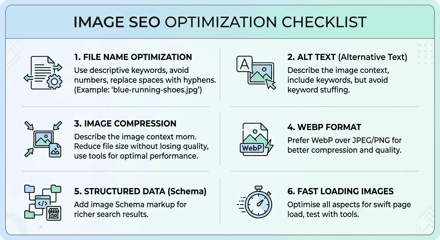
Since geotagging offers limited direct benefits and carries privacy risks, your focus should shift to Visual SEO, techniques that are proven, safe, and officially supported. These practices improve search visibility while enhancing user trust and engagement.
1. Use Descriptive, Localized File Names
File names provide search engines with a basic clue about your images. Generic names like “IMG_001.jpg” convey nothing, while descriptive names give context.
Tips for file naming:
- Be concise but descriptive (2–5 words is ideal)
- Include local context naturally without stuffing keywords
Examples:
- Poor: best-plumber-near-me-in-austin-texas-78701.jpg (spammy, overstuffed)
- Better: residential-water-heater-repair-austin-tx.jpg (clear and localized)
Hyphens separate words for search engines, making it easier for AI to understand the content.
2. Craft Effective Alt Text and Captions
Alt text serves two purposes: it informs search engines about the image and improves accessibility for users with visual impairments.
Best practices for local SEO:
- Describe what’s in the photo
- Include location naturally when relevant
Example:
alt=”Exterior of our boutique bakery in the historic district of Prague”
Captions and nearby page content also reinforce local relevance. Place images close to headings and descriptive paragraphs to strengthen contextual signals.
3. Focus on Technical Performance and Modern Formats
Site speed affects rankings and user experience, especially for mobile visitors. Large images are a common cause of slow loading.
Recommended formats for fast-loading, high-quality images:
| Format | Benefits | Recommended Use |
| WebP | ~30% smaller than JPEG | General-purpose web images |
| AVIF | 50%+ smaller than JPEG, excellent detail | Hero images and product galleries |
| JPEG/PNG | Universal compatibility but larger | Fallback for older browsers |
Additional tips:
- Use responsive images with the <picture> element
- Enable lazy loading for off-screen images
These methods ensure pages load quickly without sacrificing visual quality.
4. Implement Structured Data for Explicit Local Signals
Structured data provides machine-readable information that search engines can trust. Using schemas like LocalBusiness or ImageObject, you can include:
- Business name, address, and phone (NAP)
- Geographic coordinates
- Hours of operation
This approach is more reliable than embedding hidden GPS coordinates, as it ties location directly to your official website domain.
5. Prepare for AI-Driven Visual Search
Local search is increasingly powered by AI systems that summarize and interpret content, a trend sometimes called Generative Engine Optimization (GEO).
- Traditional Q&A sections on Business Profiles are being replaced by AI-powered conversational tools.
- If a customer asks, “Does this cafe have outdoor seating?” AI will scan images to answer.
- Missing or unclear photos may result in lost opportunities.
Implication: Your photo gallery should visually document your business’s key features, from signage to seating and accessibility.
6. Use Metadata for Provenance and Transparency
With AI-generated imagery becoming common, metadata now serves to signal authenticity:
- Use IPTC standards to label images as AI-generated or AI-manipulated
- Prioritize original photography to maintain trustworthiness in search results
Strategic Recommendations for Local Businesses
Evidence from technical standards, experiments, and search engine behavior leads to a clear conclusion: geotagging is no longer a primary ranking factor. Instead, invest in comprehensive visual SEO.
Actionable Steps:
- Prioritize Authenticity: Replace stock images with real photos of your team, storefront, and products. Authentic visuals build user trust.
- Optimize for AI Vision: Ensure key features (signage, menus, accessibility) are visible. Search engines now interpret these images to answer customer queries.
- Strengthen On-Page Context: Use descriptive file names, localized alt text, and relevant captions to reinforce local relevance.
- Leverage Structured Data: Implement JSON-LD schema with NAP, coordinates, and hours for explicit, verifiable location signals.
- Maintain Technical Excellence: Adopt modern image formats (WebP, AVIF), responsive layouts, and lazy loading for fast performance.
Conclusion
Geotagging is largely a relic of past SEO tactics. While harmless to include naturally, it should not drive your strategy. Modern local SEO success depends on:
- Clear, authentic visuals
- Fast-loading, technically optimized images
- Structured, context-rich data that search engines can trust
Focusing on these elements ensures your business meets both user expectations and the evolving demands of AI-driven search.
FAQs
Does geotagging images improve local SEO rankings
Geotagging alone is not a confirmed ranking factor for local SEO. Studies show that embedding GPS coordinates in photos may help hyper-local “near me” searches but does not consistently improve city-wide visibility. Focus instead on authentic, high-quality images and structured data for better local search results.
How can I optimize images for local SEO?
You can optimize images by using descriptive, localized file names, writing detailed alt text, placing images near relevant content, and using structured data like LocalBusiness or ImageObject schema. Fast-loading formats like WebP and AVIF also improve mobile performance and overall SEO.
Are there privacy risks with geotagging photos?
Yes. Geotagged photos can reveal personal or business locations to unauthorized users. This can increase risks like cyberstalking, targeted burglary, or privacy breaches. Disable location services when capturing sensitive images and consider delaying posts until after leaving private locations.
Why are authentic images more important than stock photos for local SEO?
Authentic images help build user trust and engagement. Consumers are more likely to interact with real photos of your storefront, team, or products. Listings with genuine visuals receive higher click-through rates, more direction requests, and greater overall engagement compared to stock imagery.
How does AI and visual search impact local SEO?
Search engines now use AI and computer vision to analyze images, reading signage, menus, products, and landmarks. These visual signals can confirm location and business relevance without relying on hidden metadata. Clear, context-rich photos help AI systems answer customer queries and improve local visibility.